Sunday, July 29, 2007

Marinduque: Boac, Marinduque and its architectural heritage

This is day two of my Marinduque trip. We were planning to visit the Tres Reyes Islands which we saw from Mount Malindig. But we were just too tired and spent most of the morning resting. After lunch at the beach house, we went to the Boac town proper to check out the church.

It was a pleasant surprise as we got down the jeep to discover that Boac still has a sizeable collection of architectural heritage. I really didn't expect to see the town virtually intact, so many heritage houses and buildings! Although you could see that progress is fast setting in.

If controlled properly, Boac can become a great heritage town. The heritage district can be a showcase for the municipality and province and a potential tourist attraction if the heritage structures are protected, new buildings and development in the heritage district are controlled and regulated, and heritage structures properly restored.

Heritage ordinances have successfully been enacted by LGUs such as the City of San Fernando, Pampanga; Dagupan City, Pangasinan; the Province of Pangasinan; and Vigan, Ilocos Sur. These legislative measures prevent the demolition or improper renovation of heritage structures which are cultural treasures and the pride of the community. If the local government knew how to play its cards right, it would preserve the historic core so that it would become a major tourism attraction for Marinduque. I hope they realize that sooner or later.

We went up the hill to the Boac Cathedral. The exterior is still intact. But not for long because as I write, they are plastering the buttresses with cement! The interior was covered with bricks and it's obvious it isn't the original. But at least the retablos are still intact. Boac would be such a waste if people there are not educated as to how important it is to restore heritage properly.

We also got to see some morion masks in the shops. They aren't cheap though, about PHP4,500 per mask. From Boac, we took a jeep to Balanacan Port in Mogpog for the 4 p.m. ferry back to Lucena. We decided to stay at the rear end of the ferry so that we could enjoy the view. We arrived at the port three hours later and boarded a JAM Liner back to Manila.

Part 1: Hiking up Mt. Malindig in Marinduque

Related entry
Romblon, Romblon is a heritage town

Technorati Tags: , , , , , , ,

Saturday, July 28, 2007

Marinduque: Hiking up Mt. Malindig in Marinduque

I climbed another mountain today. Mount Malindig is the highest peak in Marinduque. For a second climb, I was told, Malindig was something. And imagine, my first was also a Level 2. What a consoling thought for the blisters I got!

From the Buendia LRT Station, we took a Jac Liner bus to the Dalahican Port in Lucena, Quezon (PHP193). I was with Gideon Lasco and Sharif Gonzales. Sai Sicad followed, taking a bus from Cubao. Our bus arrived at the port just in time for the 2 a.m. departure of the ferry to the Balanacan Port in Mogpog, Marinduque (PHP125). But Sai arrived a minute late (we actually saw his tricycle arrive at the port as our ferry pushed away) so he had to take the 3 a.m. ferry to Sta. Cruz, Marinduque. So plans changed and we met up with him there.

We arrived in Balanacan at about 5:30 a.m. Vans were waiting outside and we took one to Sta. Cruz (PHP70) to meet up with Sai. At Sta. Cruz, we had breakfast at Rico's Inn and checked out the old church. The church and retablo was intact. From there, it was a jeep to Torrijos where we took a jam-packed tricycle (there were ten of us including the driver) to Brgy. Sahi in Buenavista, the jump off point for Mount Malindig. Just look for the tricycles to Malibago and ask the driver to take you further down the road to Sahi.

The forested volcano of Malindig, previously known as Marlanga, is located at the southern tip of Marinduque. The climb is usually 1 hour and 30 minutes. But with me around, it took 3 hours to get to the base camp which is about 900 meters above sea level. Unlike the Pico de Loro climb which was rainy, muddy but forested, the Malindig climb was scorching hot with no trees to give us any shade. but the views were fantastic such as the Tres Reyes Islands named after Melchor, Gaspar and Balthazar.

We wanted to be back down before dark so that we could pass by the Malbog Sulfur Springs so I decided to stay behind at the base camp (to speed up things and to recharge) while the rest went up the summit which is 1,157 meters above sea level. There's no view up the summit since it's covered by thick forest growth. The best view is from the base camp where according to Gideon, you could see many the major mountains in Southern Luzon including those in Romblon, Mindoro, Batangas, Laguna, Quezon and the Bicol Region.

Our descent took just an hour. Back at the jump-off point, we took a tricycle to the springs in Malbog. We had to cross a small river to get to it. The group only stayed for a while since we wanted to be in Boac before it got really late.

On the way to Boac, we stopped at the town of Gasan for dinner. I was surprised to see some good places to eat. We picked an Italian sounding restaurant which did serve pasta and a variety of American and Filipino dishes. It was value for money since I got pasta for three (the menu says good for two) for just PHP70! Everything was so cheap. We also got ourselves some tuba to drink at the beach house.

For the night, we stayed at the private beach house of Lizel, Sharif's girlfriend. The last photos are some experiments I made with my camera. Those are night shots, quite dark when I took them, but with super long exposures. See the stars?

Part 2: Boac and its architectural heritage

Technorati Tags: , , , , , , , , , , , , ,

Wednesday, July 25, 2007

Manila: Bring back the good old days at the Met

I've been gathering information about conservation projects all over the country for a report I will be presenting at a seminar next week. So I passed by the Metropolitan Theatre, which I believe is the most prominent heritage structure currently undergoing restoration. Yes folks, they're restoring the Met!

I was toured around by Archt. Richard Bautista of the NCCA. Indeed, the interiors and exteriors will make you go loco over Deco! For more information on the project, check out the article which I posted as a comment below. Calling all Met alumni, I think a fund-raising reunion concert is in order. What do you think?

I also checked out the Arroceros Forest Park. Well, it does not look like a forest anymore. How sad it was to see a concrete covered forest no thanks to Atienza. It's now the Arroceros Concrete Paver Park with matching building at the entrance. Indeed, Atienza deserves the tag "Butcher of Arroceros" for the travesty he committed.

Anyway, since the park is along the banks of the Pasig River, you could see two bridges namely the Quezon Bridge and the Ayala Bridge (its precursor, the Puente de Convalecencia, was said to be have been designed by Gustave Eiffel). More photos in Multiply.

Technorati Tags: , , , , , , , , ,

Monday, July 23, 2007

Manila: Heritage updates from Manila

So much has happened the past few days. I've been so busy with work, school and all my organizations. Anyway, here's a run-down of some developments in the news:

1. Rizal Avenue old-timers welcome reopening (Phil. Daily Inquirer, 07/19/2007)
Many people have been asking about the stand of the Heritage Conservation Society regarding the reopening of the pedestrianized portion of Avenida to vehicular traffic. In all honesty, HCS does not have a stand as of yet. And admittedly, many in the HCS Board had not seen the pedestrianized Avenida for us to say something about it. So we asked Archt. Dinky von Einsiedel for his comments, he being the urban planner in the HCS Board. Here is what he said:

"I was still living abroad when I learned of the pedestrianization of Rizal Avenue. Since that time, I have been trying to get a copy of the study that led to the 'Buhayin and Maynila' program of Mayor Atienza which the Rizal Avenue project is supposed to be part of. I've been wanting to understand the background for it and whether there had been any stakeholder consultations for it. But I have not had any success. It appears that there has been no such study. And that there has been no consultation either.

"The concept and practice of pedestrianization is well-entrenched in other cities in Europe, USA, and in more recently even in China. Its a popular approach for inner city revitalization. I assumed the Rizal Avenue case had the same set of objectives. But it seems that it was purely a beautification effort. Concededly, the construction of the LRT 'killed' businesses along the avenue especially during construction. After it was completed, the structure made the avenue dark and, while business resumed, it was not as brisk as before. I interpret this to be the reason for the need to beautify the area - to make it more pleasant for shoppers. I thought it did a good job, at least when I saw it after it was inaugurated.

"But I learned later how the project was decided. The story was narrated to me by the contractor who undertook the beautification works. They were driving down Rizal Avenue one day and Atienza asked his advice on what can be done to beautify the avenue. He suggested to pedestrianize it, put in benches and plants, beautify the columns and put in lights to brighten up the underside of the LRT structure. He added that he had a lot of leftover materials from his other projects that could be used immediately. Atienza agreed and the project proceeded.

"I understand the Baywalk was similarly decided like that, as well as other projects under the 'Buhayin ang Maynila' program. There has been no comprehensive study, no plan, no consultation, nothing; just pure and simple impulsive decisions on a project-to-project basis. That's why it's prone to be derailed especially when the principal stakeholders (e.g. business owners) don't support the idea."

2. Court issues TRO stopping work on Intramuros project (Phil. Daily Inquirer, 07/20/2007)
Kudos to Secretary Joseph Durano for seeking a TRO versus Dean Barbers' illegal project in Intramuros! As the article notes: "The court said Barbers had violated the provisions of Presidential Decree No. 1616, as amended, and its implementing rules that prohibit any form of construction or repair in Intramuros without a development permit from the IA. The decree declares the entire Intramuros area as a major historical landmark."

3. Demolition of condemned Manila buildings sought (Phil. Daily Inquirer, 07/21/2007)
The Sangguniang Panlungsod of Manila passed a resolution calling for the demolition of all condemned buildings and infrastructure in the city. At face value, the resolution seems to be the right thing to do. But the problem is, many heritage buildings were inappropriately condemned by the Manila City Engineer's Office which has no appreciation whatsoever for heritage.

As Prof. Butch Zialcita mentions: "I'm afraid that the list will include [heritage] buildings. Right beside the Nakpil house is the beautiful but dilapidated Boix House which the Jesuits have inherited. City Hall engineers claim this is unsafe. But Archt. Mico Manalo, who inspected it, says it is perfectly sound except for the azotea. I am quite sure they have included other 1900s houses in Manila. Their engineers are ignorant about or are prejudiced against earlier types of buildings."

He adds, "Tourism on the North Bank of the Pasig has increased thanks precisely to these antique, but dilapidated, buildings. Carlos Celdran, Ivan Mandy, Tess Obusan and myself bring tourists (both local and foreign) around the old quarters of Manila. Regularly, members of the different embassies, French and Spanish, for instance, call us up because they want to see these 'dilapidated' but charming houses."

It would be a great loss to the City of Manila if these dilapidated heritage buildings are included in the call for demolition. It would be best if Manila restores these charming old buildings, just as other capital cities all over the world are doing.

4. Arroceros Forest Park regained (The Manila Times, 07/06/2007)
Arroceros welcomes visitors again! As Maribel Ongpin writes in her column, "For the Winner Foundation and its friends among the general public, the reopening and taking back of Arroceros Forest Park under the newly elected city administration was a bittersweet experience last Sunday, July 1. That justice has prevailed and that the public has its park back is indeed a sweet vindication of all their work and the vicissitudes they had to put up with in the past. But the changed circumstances of the park of 2.2 hectares which lost approximately 70 percent of its forest cover (as estimated by its landscape architect) to a building and a travesty of a garden was woeful."

She adds, "In this whole sorry business Mayor Atienza was the mastermind but the teachers who played the flunkeys are just as guilty for the carried out their deeds for self-serving reasons. 'There are no tyrants where there are no slaves' as Rizal acutely and sadly observed of some of his countrymen. Now the Winner Foundation picks up the pieces and moves to the future even as it rebuilds what was destroyed."

5. Resistance growing vs Atienza as DENR chief (Phil. Daily Inquirer, 07/20/2007)
After reading Maribel Ongpin's column, need we ask why? The "Butcher of Arroceros" is now DENR Secretary. Oh brother!

6. Adopt a lighthouse (Phil. Daily Inquirer, 07/23/2007)
According to Archt. Toti Villalon, there are "21 surviving Philippine lighthouses located in the deserted extremes of the Philippine archipelago, all rendered obsolete by 21st-century satellite or sonar navigational system." The answer of the Philippine Coast Guard to preserve them is the 'Adopt a Lighthouse' program.

As Villalon notes, "The Philippine lighthouses are Bagacay in Cebu; Bagato, Sorsogon; Batag, Northern Samar; Bugui Point, Masbate; Cabra, Mindoro Occidental; Calabasa, Iloilo; Canigao, Leyte; Cape Bojeador, Ilocos Norte; Cape Bolinao, Pangasinan; Corregidor, Manila; Cape Engaño, Cagayan; Melville, Palawan; Cape Santiago, Batangas; Capones, Zambales; Capul, Northern Samar; Donsol, Sorsogon; Jintotolo, Masbate; Malabrigo, Batangas; Pasig River, Manila; San Bernardino, Sorsogon; and Siete Pecados, Guimaras." Care to adopt one?

7. Pasig River runs through them (Philippine Star, 07/21/2007)
Paolo Alcazaren writes, "The Intramuros, or the walled city of Manila, is a national (and Asian) heritage site that was almost lost to the ravages of war and the post-war invasion of informal settlers. It has been slowly recovering its fabric in the ‘70s to today, hanging on desperately despite recurring threats from commercialization.

"Today, another threat is emerging, actually already rising in concrete and steel — a sports complex by the storied walls of Old Manila! The monstrous encroachment is reportedly the project of Dean Barbers, Philippine Tourism Authority general manager. Costing P85 million, the complex is being built in the Club Intramuros driving range area (itself already a blight on the landscape) and very close to the walls. The project, say sources, was rammed through despite the disapproval of the PTA board. How GM Barbers was able to do this seems incomprehensible to everyone but the contractor and workers at the construction site. Even the Intramuros Administration has issued an order for the work to stop but to no avail.

"Tourism Secretary Ace Durano apparently also seems powerless to prevent the disaster from happening. He had reportedly sent a memo to Barbers to stop construction, reminding Barbers that the project has no approval from the PTA board.

"I wish the P85 million had been spent on improving the parks and plazas of the Intramuros. The money could also go a long way to make the destination friendlier to local and foreign tourists by providing better street lighting, more security, an ikot type hop-on, hop-off shuttle inside the walls, or simply contribute to the whole areas upkeep, garbage collection and general maintenance.

"The DOT, to which the PTA is supposedly attached, has to act now or take command responsibility for this madness. The metropolis is replete with sports complexes and, correct me if I’m wrong, building these facilities is not a core function of a tourism body. Otherwise, it should be renamed the DOST, the Department of Sports and Tourism and its adjunct office, the PSTA, the Philippine Sports and Tourism Authority.

"Wow, only in da Pilipins!"

8. Mayor Lim creates Manila Historical and Heritage Commission
This is not yet in the news but I'm happy to announce that Mayor Alfredo Lim revived the Manila Historical Commission and renamed it Manila Historical and Heritage Commission. Carmen Guerrero-Nakpil will serve as chairperson. I'll send updates as soon as the group convenes. Kudos to Mayor Lim!

Technorati Tags: , , , , , ,

Saturday, July 14, 2007

Cavite: Hiking up Pico de Loro

After years of wanting to climb a mountain, I finally did today. Although I’ve climbed up the summit and down the crater lake of Taal Volcano in 1998, I consider this my first real climb. I joined the 2010 and 2012 UP Medicine students in the open climb of the UPCM Outdoor Society as they scaled Pico de Loro. The mountain is 664 meters above sea level.

Meeting time was 4 a.m. at the UP College of Medicine. I only had two hours of sleep and realized I was late. We were supposed to commute. But since there were 35 of us in the group, the organizers decided to hire two jeeps. The group left a little past 5 a.m.

We arrived at the Mounts Palay-Palay/Mataas na Gulod National Park in Ternate, Cavite about 8 a.m. no thanks to some kotong cops in Paranaque and traffic congestion in Cavite which we encountered. Pico de Loro is actually part of Mt. Palay-Palay (which is part of Maragondon, Cavite) and is said to be the highest point in Cavite. The other jump-off point for the mountain is in Nasugbu, Batangas. After registering at the DENR outpost, which is up the road from the gate of Puerto Azul, we were off.

It was a difficult first climb for me. We had not even reached the base camp but I was already panting badly since we had to go up and down Magnetic Hill and walk a distance more to get to the base camp. I was actually part of the lead pack and was able to follow them up to the foot of the mountain. But then my legs gave way and I ended up at the end. Talk about being physically pfffft! Add to the fact that it started to rain really hard and the path started to get muddy and slippery.

Poor sweepers, they had to keep me company as I made that arduous climb to the top. We made our way through forested areas and grasslands while the heavens opened its flood gates. Indeed, it was being one with nature. The push up was forgettable to me since I have difficulties hiking upwards. Good thing the refreshing view of the lush forests kept me going.

Then I heard the group from a distance. I was nearing the peak area. And finally, the last person up made it. And that was me! But the experience on top was unbelievable with strong gusts of wind and rain hitting the mountain. I just stood there, awed by nature’s force.

We had lunch at the peak area. I just brought crackers to fill me up. Most of the group went up further to the pillar area. But I was having cramps and opted to stay with the others who remained. Then they gave us the go signal for the descent as the rest of the group was making its way down from the pillar area. I decided to go with the first group since I knew I hiked slower and they could catch up with me anyway. For the most part, I hiked down alone, absorbing the view of the green forest around me. In fact, it was smooth sailing for me and I thought to myself I would be back in the DENR outpost in no time.

I caught up with the lead pack at the base camp and joined them when they left the camp. We were warned by the caretaker about a very confusing fork but I didn’t get the details since the others took care of that. But to make the long story short, we missed that confusing turn. Poor me, I got an "extra" hike since we ended up walking towards the Maragondon Trail which was longer, muddier, narrower, and more slippery. And we only realized it after 40 minutes walking along that very, very muddy trail. Imagine we had to walk back the same trail.

It was getting dark and my group was pushing me to hike faster so that we could make it back before it got real dark and visibility became zero. Until we finally found the confusing fork, and I ranted that DENR or whoever manages the park knows so many people miss that fork, why don’t they put up visible signs pointing hikers to the right direction! Well, it wasn’t over since it was still a long hike up Magnetic Hill. Damn!

No amount of words could describe how I felt when I saw the road. Arriving at the DENR outpost, the feeling of relief when I sat on the bench was indescribable. Over-all it was all fun, but hell while I was hiking up. Haha! And to think that was just a Level 1 climb.

More photos in Multiply. Thanks to Siena Ona, Gideon Lasco, David Chan, Alric Mondragon and the rest of the gang for a great climb. Thank you as well to Sai Sicad (who was also a guest climber) for giving me that extra push on the way up the summit. Same goes to the lost group (Paolo Macasaet, Zhamir Umag, Angel Palabyab, Joseph Macaraya and Leah Mislang) for waiting for me every time I had to stop to catch my breath. And thanks to my brod Lemuel Narcise for inviting me. Should I climb another mountain?

Technorati Tags: , , , , , , , , , , ,

Thursday, July 12, 2007

Siquijor: DPWH stupidity strikes again!

Remember that unfinished bridge the DPWH built in Loboc, Bohol (picture below) which was discontinued since it was going to hit a national cultural treasure, the Loboc Church and Belfry? Well, DPWH's lack of common sense is at it again. And this inutile agency will be damaging another national cultural treasure, the Lazi Church and Convent in Lazi, Siquijor.

According to the NCCA, the Lazi Church, which features wide wooden floorboards and coral stone walls, was built in 1857 by the Augustinian Recollects. It occupies two town blocks with a road separating the church and its large convent. And the DPWH is raising the said road by more than a meter! How stupid can they get? It's totally absurd given that the church, convent and the road which runs in between them are 30 meters above sea level.

Faisal Alih sent us this alarming picture. He notes that vehicles can no longer enter the convent grounds. He also pointed out that people will have a hard time walking between the two structures. The idiots in the DPWH reasoned out that they will build steps down anyway, but that's beside the point since the features of the place will be destroyed.

Jun Galang adds, "The important question is, are there floodings on the road that is the reason behind the construction? If there aren't, then the church will be endangered since water will flow from the street to the church compound, increasing humidity." He adds, "If the road runs in betwen the church and convent, the resulting elevation will ruin the harmony of the complex!"

It's time to move again! Mind you, it's the same DPWH regional office which built that stupid bridge in Loboc, Bohol, tried to demolish the centuries-old houses in Baclayon, Bohol and destroyed the Spanish and American colonial bridges in Alegria, Cebu. Let's all write or call the DPWH:

Hermogenes E. Ebdane, Jr.
Secretary
ebdane.jun@dpwh.gov.ph
(02) 3043221

Jerome M. dela Rosa
Director, Region VII
Region VII District Office
(032) 2348014

If the public was able to stop the construction of the bridge in Loboc, Bohol and the demolition of ancestral homes in Baclayon, Bohol; I'm sure we can also prevent the completion of this brazen disregard for heritage and utter lack of common sense which the DPWH is doing in Lazi, Siquijor.

Loco Loco Over Deco!
Shanghai... New York... Bombay... Miami... Rio de Janeiro... Manila... separated by oceans, continents, and time lines, what do these cities have in common?

Not much, except all cities are a treasure-trove of Art-Deco architecture! Come and take an arm-chair journey down the roaring 20's as we explore Manila's rich Art-Deco heritage! It's all about the age of speed, jazz, boogie-woogie and the American colonial experiment in the Philippines, do swing by and join us as we gather together and go loco over Deco!

Speaker: Ivan Man Dy
When: July 19, 2007 Thursday 6:00 PM
Where: Ortigas Foundation Library
For more information please call 6311231 local 222 (look for Aileen Matic) or e-mail ortigasfoundation@ortigas.com.ph

Technorati Tags: , , , , , , , , ,

Saturday, July 07, 2007

Palawan: Underground river and more from Puerto Princesa

It’s been quite a while since the Philippines has had a new UNESCO World Heritage Site. The latest was still way back in 1999, with the inscription of two sites, Vigan and the Puerto Princesa Subterranean River National Park known as the Underground River.

Batanes has tried several times to get in the list but never seems to make it because of human error I was told. Besides, some experts say Batanes is not ready for inscription. Aside from being culturally significant and well-preserved, the host community has to be ready for it. That means that the ordinary man on the street should know about the UNESCO inscription, how it will affect them, as well as the duties and responsibilities that accompany such an inscription. The Underground River is a prime example of how a local government, with the right political will and proper guidance from experts, can push proper conservation policies that could lead to inscription.

The park is the only one that is managed by a local government unit in fact. It was under the care of the Department of Environment and Natural Resources (DENR) before. But illegal logging was rampant. Newly-elected Puerto Princesa mayor, Edward Hagedorn brought then DENR Secretary Angel Alcala to the park to show him the illegal logging activities of the DENR personnel. This resulted in a memorandum that turned the whole area over to the city government.

Lucky day 07-07-07 was spent at the Underground River today via another group tour I booked from my hotel. According to UNESCO, “The Puerto Princesa Subterranean River National Park features a spectacular limestone karst landscape with its underground river. A distinguishing feature of the river is that it flows directly into the sea, and the lower portion of the river is subject to tidal influences. The area also represents a significant habitat for biodiversity conservation. The site contains a full mountain to the sea ecosystem and protects forests, which are among the most significant in Asia.” This was the reason justification for its inscription in the prestigious list.

The ride to Sabang Beach, the jump-off point for the Underground River, is about two hours from the city center, with two stopovers: one as you leave the National Highway, and another at the Buenavista View Deck where you could savor a panoramic view of Ulugan Bay.

At Sabang Beach, you had to visit the park office to get a permit to visit the Underground River and book your boat to the river entrance. You could also opt to hike 2.1 kilometers up and down a mountain trail from Sabang to the river entrance. The group tours are really convenient since they took care of all the logistics. The PHP1300 I paid includes hotel pick-up, land travel to and from Sabang Beach, boat transfers from Sabang to the river entrance, all entrance fees, and lunch.

On the boat on the way to the river entrance, we were afforded stunning views of the limestone karst landscape that characterizes the park. The boat passed by a beach which I remember from my trip in 1997. Swimming is not allowed in the river entrance area which is why you had to hike up and down the Monkey Trail to get to that beach to swim.

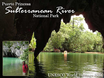
At the river entrance, you had to sign their register, wear life jackets and protective helmets, and wait in line to board small boats with outriggers that would take you into the cave. Each boat had a battery-powered lamp in front which I would later find out while exploring the area, were charged with solar energy. Our boat guide was Toting, who is the most popular of the guides for his humor. In fact, he is sought after by visitors and is the one who appears when the Underground River is featured on television.

Indeed, he was hilarious, cracking jokes every now and then, breaking the silence inside the cave. It was a different world we entered, one covered in complete darkness, pierced by the solitary spotlight we had on board. Looking up, you would see different species of bats hanging from the ceiling, fast asleep. Their presence was obvious due to the pungent odor of guano, or bat dung, close to the mouth of the cave.

Flying around were cave swiflets (not bats as others mistake them for) that are most known for the nests they create from their saliva that become the main ingredient of nido soup. The formations inside the cave are spectacular. The speleothems (the cave formations or secondary mineral deposits) formed by thousands of years of mineral accumulation, were very interesting.

The Underground River in Puerto Princesa is the longest explored underground river in the world. A total of 8.2 kilometers have been discovered; 4.3 kilometers are navigable; but access to tourists is limited to 1.5 kilometers. You’ll have to get a special permit to explore the rest of the river.

Anyway, the tour inside the cave lasted about 45 minutes. In the picnic area, lunch was served by the guides. Just a warning though, watch out for the long-tailed macaque monkeys. If you let down your guard even just for a while, you might lose your lunch to them. Monitor lizards or bayawak also walk freely in the area.

After lunch, our group made its way back to Sabang Beach, and then the city center. But we made a brief stopover at Viet Ville to have more Vietnamese food. This time, I ordered chicken salad and beef ball soup.

Back in the city proper, I took a quick nap before heading to Balinsasayaw Restaurant where our group decided to have dinner. It was a full menu of nido soup, grilled meat and sea foods, and garlic crabs for us. Thanks to Oliver Banzon, Em’s friend, for treating us to a sumptuous dinner. The night wasn’t over since Rolly and Gigi Padilla treated us to drinks at Itoy’s Coffee just across the street. It was our last night and I was taking the Cebu Pacific flight back to Manila the next day. Although Rolly and Gigi were still staying another day for a Dos Palmas tour which completes any Puerto Princesa holiday. More photos in Multiply.

Friday, July 06, 2007

Palawan: Island-hopping in Honda Bay

Today I went island-hopping in Honda Bay, which consists of several islets that have become popular swimming, snorkeling and diving destinations among visitors. Visiting the different beaches was a great way to celebrate my 28th. Located in Sta. Lourdes, Puerto Princesa City about 12 kilometers east of the town proper. In the wharf, pump boats could be hired to the different islands. Some islands require entrance fees. And there are others which are privately owned. So you have to ask for permission to visit. The package tour (PHP1000) is inclusive of hotel pick-up, pump boat to the different islands, entrance fees and donations, and lunch.

Our first stop was Pandan Island. There are several huts and cottages on the island which visitors could use. You could also ask caretakers to get some coconuts to quench your thirst. Snorkeling was great around Pandan Island. And it was fun feeding the fish since they all swam towards you as you hold a piece of bread.

After an hour or two, we moved to Snake Island which was a two-kilometer sandbar shaped like a snake. It would have been fun to walk up to the end of the sandbar, but half way there, we started to get hungry. And high tide was setting in with parts of the sandbar starting to get submerged under water. So we decided to walk back to the huts where our tour operators served lunch.

Our last stop was Starfish Island. We got there just in time since it started to rain really hard and the winds started bring in strong waves. Starfish is known for its fine white sand and clear water that teems with starfish. The island had a sandbar encircling a lagoon which was a good thing since we were able to enjoy the warm water sans the strong waves.

Other islets in Honda include Cannon (Cowrie) Island, Bat Island, Lu-Ii Island (from "lulubog-lilitaw"), Meara Marina, and Senorita Island (the breeding site of lapu-lapu fish).

For dinner, we ate at Rene's Saigon Restaurant for some great Vietnamese food. It was a distance from the city center, past the airport in fact. But people frequented it despite its distance. When you take a tricycle, tell them you want to go to the chawlungan since they are not familiar with the restaurant name. I had my favorite bánh mì sandwiches and braised beef noodle soup. Thanks again to Rolly and Gigi for treating us out to dinner.

After dinner, we trooped to Legend Hotel where Rolly and Gigi were staying. We stayed at the lobby to chat and have some snacks when Mayor Hagedorn passed by. Anyway, we have another trip tomorrow and have to get up early. More photos in Multiply.

Technorati Tags: , , , , , , , ,
Related Posts with Thumbnails